
Pemigewassett Loop
Lincoln, NH

July 2, 2017
------------------------------------------------------------
The Pemigewasset Loop (called "Pemi Loop") is a mixture of various connected trails (it is not a trail itself) in the White Mountains of New Hampshire that encircle the Pemigewasset Wilderness. The trip is tackled by many as a multi-day hike using various huts along the way as shelter or as a day trip for faster hikers (also read: lighter packing, those who do not want to spend a night in the woods, or those naive enough to think they are 'ready').
The loop includes 9 of the 48 New Hampshire 48 4000 footer peaks with options to include others on side trails. Each peak and the ridges along them offer picturesque views of the surrounding wilderness (when the weather cooperates). But don't be fooled, the loop was rated as the 2nd hardest day hike by Backpacker Magazine in 2005. At 31.5 miles with approximately 18,000 feet of elevation change (9k up, 9k down), this is not a simple walk in the woods (as I found out the hard way). However, for those seeking adventure, amazing views, and lots of like minded outdoors-oriented friends, I highly recommend it; or just parts of it.
------------------------------------------------------------
The views tell 90% of this story, so I am going to let them do just that. I'll interject with words to fill in with funny or background stories, but feel free to browse through the pictures.
I want to start by saying that I am incredibly thankful that my friend Jenn let me tag along on this adventure. The plan was to trail run/hike the Pemi Loop. We've both done ultras - 50ks, 50 milers. We both love to run and be outdoors. We both love adventure. The Pemi Loop seemed like a great idea. ...until about 15 miles in.
I (and I do believe we, though I won't speak for Jenn herself) found out the hard way that this is one tough day. But don't let that deter you because I would sign up for another round in a heartbeat (once my legs recover). I could go on for days about the views, the fun of the terrain, the people we got to meet, and the sheer adventure the trail provided (through the good and bad moments). I won't be able to expel all of my emotions into words, so take to heart that I sincerely hope that these pictures are all worth the words I am unable to find. Let the adventure begin!
The Pemi Loop Adventure
This adventure almost didn't happen thanks to the weather forecast. I returned home from Lake Placid, NY to find Thursday through Monday full of rain. The plan was to find a day over the weekend to head up and make a day trip of the hike; we were flexible on what day. Thankfully as we hit Friday night, Sunday began to clear up. We both packed all the gear we MIGHT need (overpacking for sure) and headed up Saturday afternoon.
On our way, we hit a storm cloud that was incredible. The car was hydroplaning on the flat highway within minutes of the storm hitting. Hikers on the trail had plenty of stories about being caught in it and how it was the worst storm New Hampshire has had in a long time.
Once we arrived, we unpacked, got dinner at Enzo's (delicious pizza!), and spent the night going through multiple versions of what to pack. Sure, we've both done ultras, but this adventure was going to be unaided except for one hut halfway through. We planned for the worst and went to bed.

A good friend of mine who knew the Pemi Loop really well mentioned that he completed it (hiking) in 15 hours. We used that as a reference and planed on roughly 14 hours total. We were going to run what was flat anyways! Oversight #1.
As a racer (triathlete), I tend to stick to the rule "Nothing new on race day." Today had multiple exceptions. My shoes had only been tested for one hour. I wore a brand new pair of shorts. I wore a pair of socks I've only ever used during a normal day walking around at work. Thankfully, all of those worked out perfectly!! I should try more new things!!

With 14 hours in our heads, we got to the Lincoln Woods parking lot and headed off at 5:20am. We'd be back at 7:20pm if all went well. Sunset was at 8:30p, so we had roughly an hour to play with.
 |
| The map at the Lincoln Woods trail head |
 |
| You Are Here. Be back in 14 hours (we think)! |
 |
| Essentials? We had 7 if you count a makeshift first aid kit. |
 |
| Here we go! |
 |
| Three days of rain made for fast moving water! |
 |
| You start with 1.4 miles on the Lincoln Woods Trail |
 |
| Turn onto the Osseo and head to Mt. Flume |
 |
| Follow the Yellow blazed trail |


The beautiful part about trails is that time goes by so quickly! Jenn and I chatted once we hit terrain we couldn't run heading up to Flume and before I knew it, we began to start popping up above treeline.
And 2 hours had already gone by!!!

 |
| There are some steep sections to get up to Mt. Flume |

 |
| New growth on the trees |
 |
| A side trail (we didn't take) - continue on Osseo |
 |
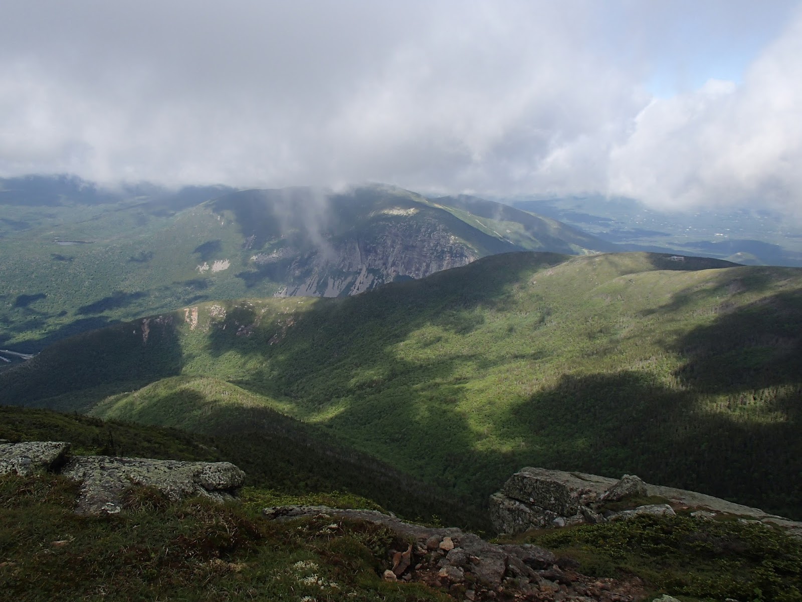
| Panoramic view from on top of Mt. Flume (for the moment the mist went away) |


Unfortunately, we had quite a heavy mist/fog atop most of the initial peaks and Franconia Ridge. I kept taking pictures laughing at the "gorgeous view" that was certainly beyond it.
Every so often, the wind would blow it away for 5-10 seconds and we'd get a glimpse, but then it was gone.


Mt. Flume (#1) done!
At the top, we met a group of three hikers doing the loop as a multi-day adventure. This was our first comment of "Oh, wow!" from hikers when we said we were doing the whole loop in one day; a sign of what we'd learn eventually - it's an undertaking.
We also met a couple who were hiking Mt. Flume and Liberty. They had started at 2 am. Not only did they hike a decent amount of the climb up Mt. Flume in the dark (impressive), but they told us all about the moose that they came across on the trail. Scary!! On top of it, the guy offered us food when he heard we were doing the whole loop. We brought our own and declined the offer. Thankfully we did in fact bring enough food.
I loved hearing the stories so much that I kept this up with most everyone I came across - asked them what they were doing, where they were coming from, etc. A few were rather quiet (maybe just hungry or rushed), but most were happy to sit and chat about their adventure and ask us about ours. What an incredible day chatting with absolute strangers.
 |
| Very different growth heading to Mt. Liberty |
 |
| Geological stamp for measuring height on Mt. Liberty |


Views from on top of Mt. Liberty


Mt. Liberty (#2) done!

Note how quickly the mist comes and goes along with the noise from the wind.


Again, another change in surroundings heading from Mt. Liberty to Mt. Little Haystack.


Changing now to the Franconia Ridge Trail. This is part of the Appalacian Trail (AT) and quite a popular ridge to hike as a single day adventure.
 |
| Onto the AT |
 |
| Shelter!!! ...just in case. |


What a view atop Mt. Little Haystack! Haha

Mt. Little Haystack (#3) done!
Then it was quickly off to Lincoln. To be honest, in the mist, we had to ask other people if this was it. Agreement among our peers nearby was Yes, this was Mt. Lincoln. "We'll take it!"

Mt. Lincoln (#4) done!
 |
| Oh, the wind!! |
 |
| Onto the ridge! |
 |
| Heading to Mt. Lafeyette |
 |
| Misty views on the Franconia Ridge |


A moment the mist blew away. Pictures!, quick!!


 |
| See! We did run (some). |

 |
| Partially misty views on the Franconia Ridge |
 |
| Geological stamp on Mt. Lafayette |


Mt. Lafayette (#5) done!
 |
| Off to Mt. Garfield |
 |
| Lots of rock cairns on the trail as markers. |
 |
| Nope! Not runnig down a rock cliff. |
 |
| Misty! |
 |
| Not misty! |


Can you tell which way the wind normally blows?


Three days of rain gave us a lot of puddles to maneuver around. Which at times just became ways to cool our feet off.


Mt. Garfield!
 |
| Trail stalkers! |

Mt. Garfield (#6) done!
 |
| The view from Mt. Garfield |
 |
| Onto the Galehead Hut (halfway point) |


One of the multi-day hikers told us about being caught in the storm the night before and because his group HAD to get to the next hut, they were forced to climb these rocks as it felt like a river was roaring over them. Their packs were soaked, clothes were wet, rocks were slippery, and it was getting dark. What a story and we began really admiring those who were out in the storm no matter what terrain they were on at the time.
But then we got to said rocks and OMG!! It was a bit tricky climbing down them with water running over them (trying not to slip as they were really steep). But if there was a river running over them, we may have turned back.
 |
| 2.2 miles to go. That's... 2-2.5 hours?! We got this! |
 |
| The mist had finally disappeared for good. |
 |
| Snack time #2. |
For the first half of the hike, I got through 2 pb&j sandwiches and 1 clif bar with nut butter. It was great, but I did notice that we weren't chatting as much in this push from Mount Garfield to the Galehead Hut. It was a climb, so I figured we were just saving our energy. I learned differently once we got there.
 |
| Glorious!! |
The first 1.4 miles of this loop on the Lincoln Woods Trail was pretty quick. The 1.4 miles from Garfield to this sign was LOOOOONG! We were so happy to see this sign. Only 30 minutes or so now.
Then I ran out of water. haha What timing!
 | ||
| We made it! |


The Galehead Hut was incredible!! Bathrooms, potable water to refill, baked goods, and if you had reserved a bed, a place to rest for the night.
Jenn and I hit the bathrooms, had some baked goods, and refilled our hydration packs while we rested for a bit.
And without doubt, along came our hiking stalkers.

 |
| Our one side trail for an additional mountain. |


 |
| View from the Galehead Mtn Overlook |
 |
| Galehead Hut from Galehead Mtn overlook |

Mt. Garfield (#7) done!
If you climb Galhead Mountain, know that the overlook is much better than the peak. We got to the peak and it's surrounded by trees. There are no views, but it still counts. Seven mountains climbed so far.
On our way up, however, Jenn pointed something out to me.
"Kurt, you're on a sugar high."
Two blondies from the Galehead Hut, a solid refill of water, and I was back to being chatty Kathy. If she hadn't pointed it out, I wouldn't have realized it. I must have had low sugar coming up from Mt. Garfield. I made a plan to try and drain my pack (2L) before making our way back past the hut as well - I'd like to rehydrate before finishing the day. I may very well run out of water again by the end.
I got about 1L in me on the Galehead Mtn side trip. Then we refilled water again, I had a number of extra cups, I ate one more blondie (wow were those delicious!), and we hit the bathroom before heading off for the 2nd half of the trip.
 |
| Off to Mt. South Twin |
Jenn warned me before starting; this was roughly 1200 feet of elevation gain in the 0.8 miles to South Twin. And it was certainly UP!
 |
| Really cool wood! |
 |
| Looking back at... Mt. Lafayette? |
 |
| Climbing up, up, and up! |


 |
| The option for North Twin. No thanks! |


South Twin Mtn (#8) done!
 |
| Off to Mt. Guyot |
 |
| Gorgeous trail! |


 |
| Too many good views to stop taking panoramics! |


Snack break!
 |
| Marks from mud slides on the mountain. |
 |
| Where we're headed |
 |
| Marble atop Mt. Guyot |


Mt. Guyot (#9) done!
Mt Guyot technically does not count as one of the NH 48 4000 footers due to something about how the elevation change from either side trail is not great enough. Either way, it's still over 4k feet tall. I count it!
 |
| Off to Mt. Bond |


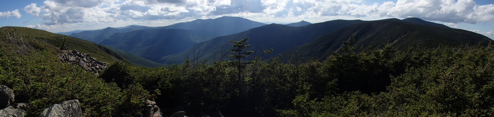
The Pemi Loop actually only barely touches the Pemigewassett Wilderness, but you do get to see it on the western side. They even mark it for you.


 |
| An option to hike to West Bond. Not today! |


Mt. Bond (#10) done! Only one left to go. And you get to see it the entire time from Mt. Bond to Mt. Bondliff.


The above view of Mt. Bondcliff from Mt. Bond allows you to gauge how far (aka. slow) you are traveling.


 |
| Caught ya!! |
 |
| I only have ten fingers, so restart! |
 |
| Oh, wait! I got something. Nope, I can't balance. |
 |
| Got it! Ten fingers and one toe. |


At the top of Mt. Bondcliff, a couple turned to us and asked "Are you Jenn and Kurt?" (*Queue that weird feeling that you're being watched*)
Our hiking stalkers who had not added Galehead Mtn to their trek were out ahead of us. They had told this couple that we were coming behind. It was hilarious! They told us we were only 5 minutes behind them. However, as with most of what people had told us throughout the day ("Just around the corner," "Oh, about half a mile more," "You're getting close," etc), we took it with a rather large grain of salt. The "Just around the corner" comment from a hiker when we were looking for Mt. Garfield turned out to be a 30-45 minute hike.
The trails truly do mess
with your sense of time or distance!

As we've been hiking throughout the day, meeting people, chatting about our respective adventures, we kept being told "Oh, so you're going to hike into the night" to which we respond "Uuhhhh, no. We should be good." Remember, we left ourselves a one hour buffer!
By the Galehead Hut, we both knew that our goal time (14 hours) was a bit out of reach. Yes, we added an extra mile for Galehead Mtn, but even with that discounted, we were not keeping up to pace. We didn't talk about it much until after Mt. Bondcliff.
We had 10-12 miles to go. About 5-7 of those were downhill. Then we'd hit the Lincoln Woods Trail and have 5 miles of flat trail. Our goal was to hit the flats before sunset. We didn't particularly want to get caught on rocky terrain in the dark.
We began jogging any terrain we could as we quietly (yes, likely another low blood sugar span) made our way down Bondcliff.


Cooling off in the cold river water!
I'd say halfway down the trail, we ran into our hiking stalkers again. They were so happy to hear that the couple on top of Mt. Bondcliff had called us out like they told them to. Haha Adventures in the woods with strangers!! The best kind of adventures.
We wished each other good luck and headed off. We both were racing daylight. They had targeted 20 hours or less for their day (having started at 4am) and we had naively targeted 14 hours (at that point likely already over 14 hours).
On we ran/hiked.
The trail became a very slow decline with a lot of mud. As many points, I began not caring to skirt the water or mud and walked right through it. We had to walk through three (or was it four) river bends. They were nice and cold on the feet and woke us up a bit.
And then we made it!!


The Lincoln Woods Trail!
We were not home yet, but we knew that we had only flat mileage left and we had beaten the setting sun. We took a quick break to grab a snack, pull out our headlamps, and were on our way.
Jenn would later tell me that around this time (as we finished the Bondcliff Trail and as we started the Lincoln Woods Trail), that I had been slurring my words. I can't imagine what may have gone through her head. haha I didn't notice a thing, but I did know that my energy was fading. I ate a pack of Clif energy chews before we started running and my mood picked back up enough to get me through.
We headed off at what felt like a brisk pace. We were roughly 4 minutes over either of our natural easy paces. The mountains had certainly done us in.

Roughly halfway back, we came up on a bridge. Jenn yelled out as it momentarily fooled her. She thought for half a second that it was the bridge back to the parking lot. We still had 2.6 miles to go.


I could have laid there and listened to the water rush by all night long! I was beat!

Onward we ran into the night.

As we made our way, we ran into a few last hikers of the day.
The first guy was rather unhappy to hear how many miles we had left. He had a large pack on and had been hiking 22 miles already. We tried to cheer him up, but didn't linger long. We wanted to get home too!
Then we ran into Andy. We had met poor Andy on our climb up to Mt. Garfield. Two of Andy's friends had convinced him (rather easily I believe) to come for "a hike" with them. They did warn him of the elevation, but Andy was a good sport and headed out. Compared to his two friends, Andy was having a rough day (as we were!) while his friends looked to be out for a stroll. Andy was doing AWESOME!
We ran into Andy's friends at the Osseo Trail turnoff. They were waiting for him to come through. I seriously hope that they bought Andy a beer, dinner, AND a solid breakfast the next day (if not a future knee replacement).
The last group we came upon were three gentlemen with large packs. They were quite happy to hear there was only half a mile left. We didn't catch names as we were all eager to push on, but we enjoyed each other's excitement in being so close to finishing the adventure.


And it was done!!

We made it back to the bridge at 9:30pm, a total trip of 16:10. My GPS had died after 14:41 total time, but Jenn's watch clocked 30.3 miles. All the maps tell us the loop should be 31.5 miles plus the extra 1.0 mile up to Galehead Mtn. At the time though, neither of us even thought to care.
My legs had agreed to run the final 5 miles and my body surprisingly felt good. As soon as we got to the bridge and I mentally knew I was done for the day, my body sent me a message....
"We're going to shut down now."
Hahaha. The 0.25 mile walk to the car may have been the toughest part of the trail, but it was worth every moment.
------------------------------------------------------------
If you ever get the chance, itch, or call to head out to the White Mountains in New Hampshire, I strongly encourage you to visit the Pemi Loop. If you'd like something smaller, check out the side trails that go up to the Franconia Ridge. As long as you avoid a foggy day, the views are incredible!
Plan out your post-adventure food beforehand!
For anyone who does tackle the Pemi Loop, I encourage you to plan your post-adventure meal beforehand. As two people from urban environments, we are used to a number of places being open quite late! We did not think about it being a small town, on a Sunday, going on 10pm when we left the parking lot. Thankfully, one place did offer to make us a takeout pizza. Glorious!! We then rested and downed two breakfasts the next morning before hobbling home.
------------------------------------------------------------
Questions
1. What is your next adventure?
Right now, I am back to triathlon season, though I may see about the Presidential Traverse later this year.
2. Have you ever done a long single day hike or maybe a multi-day hike?
This was my first long hike. I've done 3-4 hour trips before, but nothing even close to this. I'd do it again without question though. What an incredible experience!!
DREAM. BELIEVE. ACHIEVE.
No comments:
Post a Comment